
With billions of routes logged and trillions of GPS points, Strava owns the largest library of outdoor activities in the world. Here’s how it can help you.
Two months ago, my truck broke down and was stuck in the shop for 3 weeks, leaving me stranded in Salt Lake City. With work projects and travel logistics pressing, the stress began piling up. So I needed to blow off steam.
But with little beta for local adventure, what was I to do? I opened up the Strava Global Heatmap and within seconds found a nearby route to run.
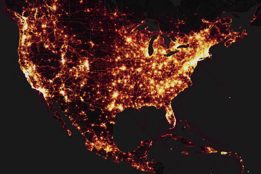
Piloted in 2014, Heatmap received a major overhaul in 2017 after high demand from Strava users. The idea behind the map is simple: It aggregates activities from Strava and highlights them on a map. Not only does this visualization prove stunningly beautiful, but it’s also extremely useful for folks like you and me.
Here’s how you can make the most of this awesome Strava feature.
What Is the Strava Global Heatmap?
The data set behind Heatmap reflects the last 2 years of activity across the globe. And it is massive!

Heatmap accounts for about 20 billion km (12.5 billion miles) of travel from 100,000 years’ worth of recorded movement. It logged some 1 billion individual public activities.
And it continues to grow.
These activities include everything from marathons to summiting Everest to skiing in Aspen. The platform allows you to select from dozens of options, including kiteboarding, backcountry skiing, mountain biking, and more.
In its first few years of existence, Heatmap collated all activities into one map and highlighted routes by popularity. This simple design worked especially well for road runners and cyclists because Strava was saturated by these two activities. But initially, Heatmap wasn’t great for everyone else. Strava began to see requests on its support pages and social media for other sports. And the brand recognized it needed to update.

How to Use Strava Heatmap
As an early adopter, I found some utility in the first release, using it primarily for road running. The interface is simple and interactive — things Strava thankfully left unchanged — meaning I could simply load the webpage, access my location, and use the visualization to quickly identify routes.
While in Salt Lake City, I often run the trails above the city, but I couldn’t get there without a car. Heatmap’s “hot spots” pointed me to a river trail just a few blocks away that even my local friends didn’t know about.

Still, Strava acknowledged it wasn’t using its extensive data set to its full potential. The new map needed to delineate sport types so that less popular activities wouldn’t get blurred out by the popularity of running and biking.
For users like me, this means the imagery I’m seeing is up to date and useful. Instead of a running a trail that was popular 5 years ago but washed out by a flood last spring, I know I can trust what I’m seeing in Heatmap to be recent data.
New Interface: Strava Heatmap
The interface now allows users to easily change the Heatmap color, opacity, activity type, and background layer to make easier route finding and discovery easier
The most important update is the ability to toggle activity type. You can select between biking, running, paddling, and skiing.

Highlighting the frequency of an activity can help locate lesser-known trails and paddle put-ins. And the Global Heatmap also allows users to load multiple activities on a singular map and differentiate activities by color.
My general preference is to turn the opacity down and select just the activity I’m interested in, then search for routes that have been run a few times but aren’t overly popular. Not only does this give user-generated beta on hot spots, but it also uncovers some hidden gems if you want solitude on the trails.
Strava Routefinder
Not only has Heatmap unlocked locations for more activities, but it may also help create safer commutes. This year, data collected with Heatmap also rolled into Strava’s new tool, Route Builder. This helps users find the best routes near them.
Route Builder overlays recorded activities onto street edges and preferentially selects routes that others have run or ridden. Unlike many other apps that rely on things like denoted bike paths or singular data sources, Strava can leverage the underlying dataset backing Heatmap to show users a safe, more efficient way around cities and trails.
