Beginning in the 1940s, the U.S. Geological Survey’s National Mapping Program was tasked with the immense cartographical feat of surveying the entire country to create a series of more than 50,000 topographical maps. Widely available and mostly accurate, the 1:24,000-scale government maps canvas the total of the contiguous United States. They are today de rigueur on outdoors adventures ranging from mountain climbs to canoe trips.
Not occurring to many people — including me! — these maps exist within the public domain and are thus free for use and distribution. Taxpayers funded the decades-long project, and now you, dear taxpayer, are allowed the keys to download thousands of maps from a U.S. Geological Survey web site.
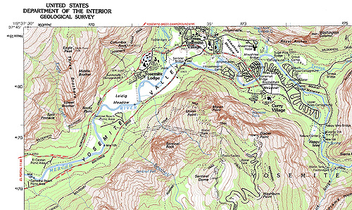
To be sure, printed maps from the USGS still come with a fee. But a download of the agency’s cartographical creations, which open in Adobe Acrobat as PDF files, is as simple and free as a few mouse clicks.
You can print the high-resolution map files from a home inkjet. Or, save the file and email a map to a copy shop for large-format print-outs.
To start the process, go to https://store.usgs.gov and find the text “Map Locator” on the top upper part of the left-hand column. Click it to be whisked to a Google Maps interface of the United States.
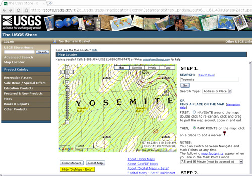
Instructions are on the right side of this page. Essentially, you can search a place name — “Yosemite,” for example — and then select from available topo maps of the area by clicking on red marker icons that pop on the Google map.
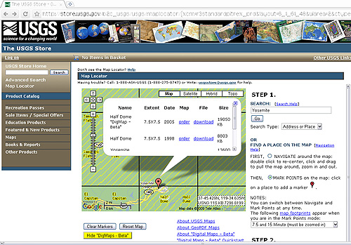
To select a map and download, click on the red marker. You will be presented with a pop-up balloon showing one or more maps in the area. Click “download” next to the map of choice, and wait as the data streams in and saves on your computer.
In my tests, the USGS site was often slow. Map data can take a long time to display, even with a fast connection. Usability on the site was only mediocre, too. I am fairly literate in the ways of the Web. But the USGS site was not entirely intuitive.
Regardless, follow the instructions close and you should have few issues. Now, go forth taxpayer! Scour the topos. Enter into the public domain. And download your maps at will.
—Stephen Regenold writes about outdoors gear at www.gearjunkie.com.