Update: See the video on our trip, “24 Hours on the Border Route,” here.
Map in hand and looking north, my compass needle spun as we approached the big rock on the top of the hill. It was mile 1 on the Border Route Trail, a little-traveled path that traverses Minnesota’s Boundary Waters Canoe Area, and the area’s weird magnetism was already altering navigation on our course. “It spins when you get close to the rock!” said Peter Wentzel, one of my hiking partners for the trip.
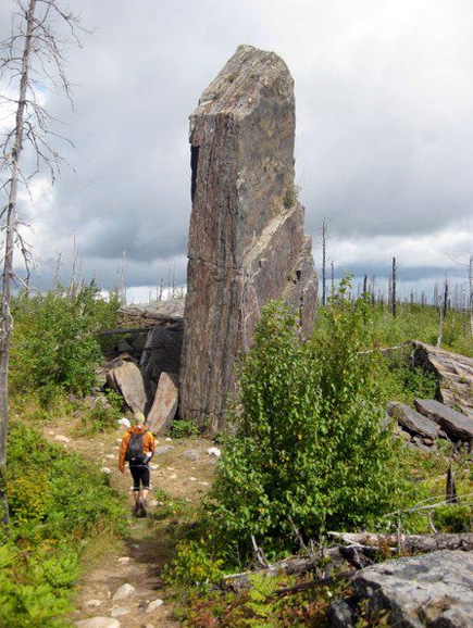
The anvil top of Magnetic Rock, a giant natural obelisk embedded with polarizing iron ore, towered overhead. Its strange pull on compass needles is known to hikers of the Border Route Trail, and magnetized ore in hills further along the path are rumored to render compasses useless for hikers trying not to get lost.
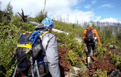
Staying on course proved a challenge during our trip over Labor Day weekend. Despite detailed topo maps and navigational know-how, my group — including Wentzel, T.C. Worley, and myself — got lost more than once on our fast-and-light trek. The Border Route Trail, created in the 1970s, is remote and hardly used. Deadfall clogs the path. Thorns and grasses drape from either edge, obscuring the 10-inch trail in hundreds of spots along its length.
We began our trek on the Border Route on a Sunday afternoon at 1:20pm. The premise of our trip was “fast and light,” and with that theme in mind we ran and hiked for nearly 24 hours straight. Our goal was to see a giant swath of the trail in short time while also pushing physical limits. A record traverse of the trail in under 24 hours would be a cherry on the sundae if we could pull it off.
In the end, we did not even come close. Our 24-hour challenge turned into 29 hours, and even then we did not make it quite to the end. But from the trailhead and nearby Magnetic Rock at the western terminus, we ran, hiked, and eventually stumbled along more or less for 52 miles before a significant rest. Then, after a rest night (pizza in town and 10 full hours of sleep!) we drove back to where we left off to knock through the rest of the trail, running much of the remaining 12 miles to the end.
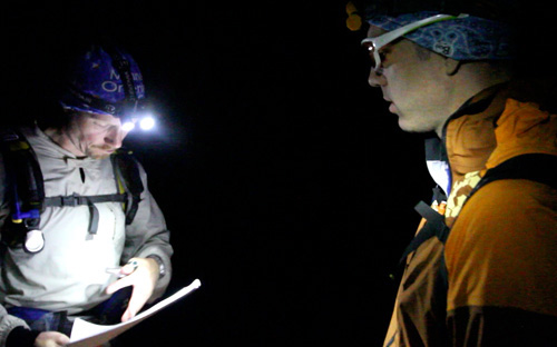
The Border Route Trail was a challenge, both physically and navigationally. We got off route and lost a half-dozen times, including a serious episode around 10p.m. the first night where our compass needles spun weird and we hiked more than three miles off route. Dazed and confused, we stumbled into a cabin settlement and sheepishly knocked on a door. “Can you guys please point us back to the Border Route Trail?” was our plea.
The cabin owner, Mitch, did more than that — he fired up a small boat and motored us across Birch Lake at midnight. Mitch dropped us off just after we saw a moose on the water’s edge, and we jumped from his small craft onto a mushy shoreline before hacking into a spruce swamp. “Keep heading east to the trail,” Mitch shouted, disappearing into the night.
We bushwhacked for 20 minutes before dropping back onto a path. Reoriented, we trekked north to again join the Border Route where we left off. Three or four hours wasted on a bad turn!
The final day, running through lowlands near the end, the trail faded in and out of existence. There was almost no trace of a “trail” for long stretches. Blue flagging tape, hung occasionally on trees, was the only savoir in the swampy bottoms near the Pigeon River.
By the end, we completed the entire trail with no injury bigger than a swollen knee (T.C.) and bruised and bashed shins (myself). The Border Route was an epic, tough trail. There were no other backpackers on the entire route. Overlooks into the Boundary Waters Canoe Area were jaw-dropping and serene. Waterfalls and rushing streams and cliffs clogged the route, and for two days the area’s loons and woodpeckers and flushing grouse provided the only soundtrack for our trip. As for our challenge, the Border Route Trail proved wild and tough — a perfect venue to push limits and revel in deep nature in the same act.
—Check out the video on Regenold and crew’s Border Route trip, “24 Hours on the Border Route.”. Connect with Gear Junkie at Facebook.com/TheGearJunkie or on Twitter via @TheGearJunkie.