Southwest Colorado’s remote Alpine Loop Backcountry Byway takes adventurers through remarkable historic sites and rugged, out-of-this-world scenery.
“No one could’ve forecasted snow,” I said to my brother, James, watching him dismount his Kawasaki KLR650 in Lake City, Colo. It was the end of June, and the cottonwoods were shedding fluffy white seeds so thick that the sky resembled a midwinter storm.
“It wouldn’t be the first time it snowed in summer,” he replied.
Along with my partner, Eric, my brother and I had met up to ride the 50-mile Alpine Loop Backcountry Byway together — our inaugural off-road trip. The high-altitude route is famous for sweeping basins of wildflowers, resounding waterfalls, and turquoise lakes. The Alpine Loop, as it’s known, connects more than a dozen abandoned and restored mines, ghost towns, and geologic gems.
Fortunately, there was no snow in the forecast up in the San Juan Mountains.

Alpine Loop Backcountry Byway
The Alpine Loop connects two high-altitude mountain passes — Cinnamon and Engineer — in a clockwise direction.
Travelers head south from Lake City to County Road 30, which veers west and climbs Cinnamon Pass with a high point of 12,620 feet. Riders then descend to County Road 20, which ascends the 12,800-foot Engineer Pass. This is the highest point of the entire circuit before riders return to Lake City, at 8,861 feet.
While the majority of the loop is on a doublewide dirt road, there are rough, technical features. The circuit is chock-full of blind curves, tight switchbacks, precipitous ledges, and a cumulative 5,600 feet of ascent — the majority of which is exposed to the elements above treeline.
Some sections are steep while others are full of loose rocks and chunky shelves. With expert-only passes like Black Bear and Poughkeepsie nearby, these two back-to-back mountain roadways seem entry-level, but that doesn’t make them easy to ride.

While there are countless significant sites to stop at while navigating this route, here’s where we spent our day on dirt:
Mile 0: Lake City
Mile 3.7: Lake San Cristobal
Mile 20: Burrows Park
Mile 23: American Basin
Mile 25: Top of Cinnamon Pass
Mile 27: Animas Forks
Mile 31: Top of Engineer Pass
Mile 38: Whitmore Falls
Mile 46: Ute Ulay Town and Millsite
Mile 50: Lake City
Adventurers can also add out-and-backs to Silverton and Ouray, which bumps the distance up to 65 miles. We packed plenty of provisions and stayed true to the central trail.

Alpine Loop’s History
Cinnamon Pass, the southern section of the loop, was built in 1874 to transport ore and mining equipment, historian Grant Houston told us at the Hinsdale County Museum. Houston is the president of the Hinsdale County Historical Society and publisher of the Lake City Silver World newspaper.
Engineer Pass was chiseled in 2 years later. By 1880, the rugged pathways became toll roads and were named the Alpine Loop.
Back then, high-alpine stagecoach travel was a romantic experience afforded by the middle class. A one-way ticket was the equivalent of $40 today. Passengers jostled around the entire time. The cheapest way to travel was by foot, and hikers still paid a toll.
Eventually, “the toll road companies went bankrupt,” said Houston. “They either gave up their charter or the county bought the company, so the tolls ceased, which is what happened on the Alpine Loop,”
Less than a decade after the heyday of toll roads, the Alpine Loop became the property of Hinsdale County, which continues to help dig out the 40-foot wall of snow atop Engineer Pass every year.
The passes are open to travelers but are not paved in winter, so they become impassable due to snowfall. The best time to ride the Alpine Loop is when the snow plug melts in the spring — late May or early June — until the first significant snowfall sometime in October.

How to Prep for Alpine Loop: Lake City
Lake City is in the most remote county in the Lower 48 and among the least populated in the Centennial State, yet the town was buzzing with activity and full of character.
Hordes of bikepackers and off-highway vehicles (OHVs) traveled up and down State Highway 149. A 1940s Jeep was parked in a front yard next to Silver Street, the town’s primary road. The wide Lake Fork of the Gunnison River flowed south through town.
I brushed cotton out of my eye, and we stepped inside the Lake City & Hinsdale County Chamber of Commerce to pick up a paper BLM Alpine Loop map and ask for route updates. We planned to head out early the next morning.
“Avoid the section from Ouray to Engineer Pass, up Mineral Creek. It’s full of sharp rocks right now that’ll tear up your tires,” advised Katrina Kent-Menzies, the Executive Director of the Lake City & Hinsdale County Chamber of Commerce.
High Clearance, 4WD Needed
High clearance and four-wheel-drive are requisite, Kent-Menzies confirmed. A Jeep Wrangler can cover the distance in nearly 6 hours. OHVs are more nimble, so they can complete the loop even faster.
“The worst vehicle you could drive is a long wheelbase pickup, which needs to go slower, and it’s harder to get around the hairpin corners, That’d require a four-point turn,” she said.
We learned more about the culture and heritage, and hiked around natural wonders and old haunts, capturing lots of photos.
Our trip was 9.5 hours door to door. We even saw a lynx! Nature gifts all kinds of treasures when you slow down.

Leave From Lake City: Alpine Moose Lodge
At 6:30 a.m., as the alpenglow hit the top of Red Mountain, I understood why the Alpine Moose Lodge was an ideal place to stay for off-roaders. Between sips of coffee and bites of cinnamon buns, we moseyed in and out of our hotel room to situate our rigs, parked out front.
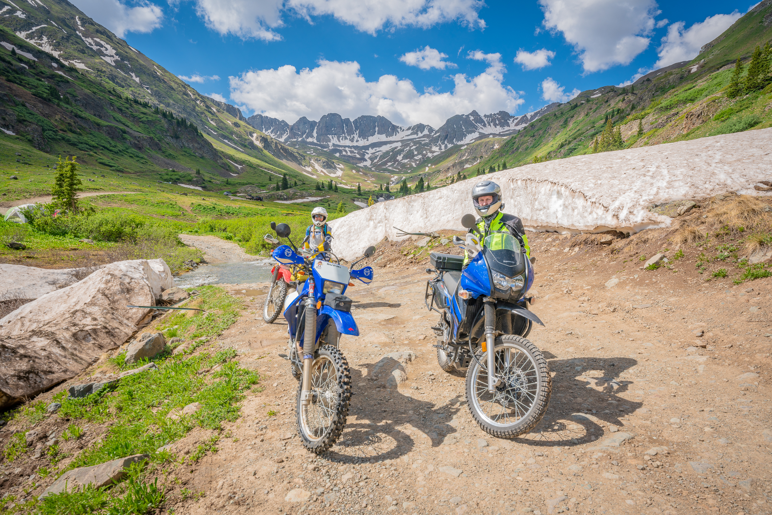
I’d recently bought a dual sport Honda CRF 230SL from a farmhand in Montrose. Eric was on his Suzuki DRZ400.
There was more than enough space to explode our gear. High ceilings helped the space stay cool. The gas pumps at the Lake City Auto & Sports Centergas station were 0.3-miles down the street.
To help ease roadside traffic in Lake City, the Colorado Department of Transportation (CDOT) Transportation Commission approved a 3-year pilot program that allows OHVs on Highway 149.
Folks can seamlessly access the Alpine Loop rather than trailer their rigs. That includes off-highway motorcycles or dirt bikes, all-terrain vehicles (ATVs), and utility terrain vehicles (UTVs).
At publication time, those vehicles are all permitted to drive the 3.3-mile stretch of highway from County Road 30 to Ocean Wave Drive from the Friday before Memorial Day through September 30, through 2023.
Lake San Cristobal
The morning air was still crisp when we arrived at our first Alpine Loop stop: Lake San Cristobal, the second-largest natural lake in Colorado.
“We’re called Lake City because of that lake, which is a tremendously scenic geologic site,” Houston said.
As we motored down County Road 30 toward Cinnamon Pass, the glassy green water stretched for more than 2 miles, reflecting the jagged silhouette of the spruce forest.
Toward the southern end, we pulled over to check out the suspension bridge built between the archipelago — not a common sight in Colorado. During the pandemic, Hinsdale County purchased the peninsula and two islands to conserve as a public park.
When I returned to start my bike, the battery was dead. Whoops. I’d gotten excited and forgot to turn off my ignition key. Eric showed me how to run-jump the moto, and we were on our way.

Burrows Park
As we moved west, the roadway started to feel more remote and unkempt. We passed the collapsed cabins of Sherman, a formerly bustling camp that served the Black Wonder Mine.
We continued north, and the southern edge of the road dropped away, becoming a precarious shelf. My eyes stayed glued to where I needed to steer.
All of a sudden, I was driving beneath a huge herd of bighorn sheep. With enormous, curling horns and giant chests, a cluster climbed the steep, craggy face above my right shoulder. I’d never been so close and in sync with these huge, wild creatures.
Ahead, we took a rest stop at Burrows Park to explore the restored historic buildings, which decorate the roadside over the span of several miles.
Today, this stretch of Cinnamon Pass is also well known for the trailheads of Handies, Redcloud, and Sunshine Peaks, which are all Colorado 14ers.
Previously, six townships existed here during the height of mining in the San Juans. It’s incredible to consider how many people lived in these isolated mountain valleys back then.
“Lake City was the metropolis of the San Juans and largest town in the state in 1877,” Houston said, “because they found very rich ore at the surface level. So rich you could hammer it and make it into jewelry. We’re in a big caldera, and the mineral seeps down through fissures.”
The ore found in Ouray, Telluride, Creed, Silverton, and Cripple Creek became more valuable with time as miners excavated deeper into the mountains.
Unfortunately, Lake City was the opposite: The ore veins decreased in richness and ran out.
“The transportation costs didn’t pay off and we spiraled downward fairly soon. We’re different than any other town in that sense. We had a brief recovery with pockets of gold in the mid-1890s through 1903, but those played out by 1910,” said Houston.
A railroad had been built in 1889. By the 1930s, the railroad lapsed, too, because it was no longer shipping valuable ore. Over the next several decades, Lake City’s population dropped from 1,500 to 100 residents, and the peripheral communities like Burrows Park dried up.
American Basin
We cruised up the next section to American Basin, one of the most photographed destinations in Colorado.
The citadel of serrated peaks is reminiscent of shark’s teeth, standing guard above a prism of blooms from larkspur, lupine, and Columbine to old-man-of-the-mountain, monkshood, and prairie fire.
Perhaps the mining bust was the best possible outcome for the preservation of this precious place. The wildflowers usually peak in mid-July.
Five of the Centennial State’s famous 14,000-foot peaks are accessible via the Alpine Loop, including Handies Peak, which can be approached from American Basin. We decided not to cross the deep creek to reach the uppermost part of the basin.
The initial climb out of American Basin was steep with off-camber, tight, steep switchbacks.

Top of Cinnamon Pass
The top of the pass delivered a bright blue sky with puffy white clouds and blustering wind. We couldn’t hear each other so we high-fived and made our descent.
I shifted into first and took my time navigating the steep downhill. Near the bottom of the pass, I picked up speed on a loose, rocky part and my bike washed out sideways. My adrenaline spiked, and I took a deep breath, trying to calm my mind.
A long line of Jeeps appeared in both directions with no way to pass until I moved my motorcycle to the side — which took a minute to achieve in the tricky turf. Thankfully, everyone we encountered was patient and respectful.
Animas Forks
We finished the ride down and took a snack break, parking on a wide shoulder with a bird’s-eye view of Animas Forks, another abandoned mining town with a handful of well-preserved buildings. Animas Forks is also the junction for Silverton or Ouray.
Despite a perfect forecast, the sky had begun to darken. We decided to be conservative, head up Engineer Pass, and skip an excursion to Silverton.
I felt warmed up and hit a flow steering my bike up the narrow, tricky switchbacks. I approached obstacles with more speed and gumption, and most of the time rode it out.
Near our halfway point along the route, which is also the most technical, there was a ton of traffic to manage from jeeps and UTVs to bicyclists and dirt bikes. Watching the traffic flow, I imagined the strings of donkeys, wagons, men on horseback, carriages, and buggies that once decorated this ground. Freighters led ore wagons, which was a lucrative job, going back and forth carrying discoveries out of the mines.

Engineer Pass
The crest of Engineer Pass is the highest point of the entire ride. With threatening weather, we weren’t sure if we’d make it to the top.
We parked, raised our arms, and celebrated. Despite being mid-summer, patches of zebra-patterned snow coated the brilliant copper, crimson, and emerald-colored slopes of the pointed peaks.
Fortunately, the rain and lightning stayed at bay. We began our final descent, passing an enormous 15-foot-high barricade of snow.

Ute Ulay Town and Millsite
We caravaned to the renovated Ute Ulay Town and Millsite, our final stop along Engineer Pass.
Formerly known as the town of Henson, this 12-acre hub is a window into the past with newly constructed trails to visit the abandoned cabins, mill, blacksmith shop, boarding house, and red-cedar water tank. This mine complex and mill operation was the primary economic accelerator that established Lake City.

Lake City
With glazed eyes and soiled jerseys, we pulled into town and ordered several double scoops of ice cream from the San Juan Soda Company.
We took a seat on the boardwalk to watch passersby. A teenage boy sat backward on his bicycle and pedaled past.
Around 1960, paved roads and reliable electricity arrived here — allowing stores to sell ice cream, for instance — and helped the town become the tourism center it is today.
Now, Hinsdale County has close to 800 year-round locals, and half that number in Lake City. Despite the huge draw of adventure travelers, this place still feels quiet.

Alpine Loop Etiquette and Rules
Over the past decade the Alpine Loop has grown steadily in popularity, said Kent-Menzies. But during the summer of the pandemic, the crowds became overwhelming.
OHVs, trucks, and SUVs drove on the area’s precious tundra. Hikers and campers left behind trash, feces, toilet paper, and cans.
“We had a huge influx of all types of visitors, many of which weren’t educated on etiquette and environmental practices. We all need to be courteous and mindful of our environment and the town,” said Kent-Menzies, handing us a pamphlet, “Know Before You Go in an OHV” with the county regulations for motorized travelers.
Here’s a rundown of the etiquette:
- Stay on designated roads
- Obey posted signs for trails and parking — and no parking on fragile tundra
- Drive slow to reduce noise and dust, and respect wildlife and non-motorized travelers
- Drive with patience
- Leave No Trace including packing out trash and human and animal waste
- Let others pass in appropriate spots
- Use hand signals to show the number of people in your group
- Watch for oncoming traffic
- Hug your side of the road on blind curves and honk to warn oncoming traffic
- Uphill traffic has the right of way
- Do not park or stop on narrow sections of road
- Use pullouts or wide shoulders to park
- Drive the Alpine Loop clockwise
At the end of riding the Alpine Loop, I was exhausted, sore, and still pumped with adrenaline from a big day outside on motos in the best of company. Experiencing this remote adventure was also the perfect stepping stone for me to expand my comfort zone on my bike.
As someone who loves deep-diving into mountain history, my cup was refilled by looking into the past, from our visit to the Hinsdale County Museum to viewing renovated miners’ cabins and walking through the Ute Ulay Town, mill, and mine site.
The verdict? I’d go again.


