
This story was co-published with Re:Public Lands Media, an independent, nonprofit news organization. Sign up for Re:Public’s newsletter.
I’m lying down in warm sunshine, surrounded by reindeer lichen growing like a forest of miniature cauliflower trees across the hillside. It’s 8:34 p.m. on July 1, my 29th birthday.
Despite the late hour, the sun is still high in the western sky. We are about 160 miles north of the Arctic Circle, where in the middle of summer, there is never true darkness. We’ve spent much of the afternoon resting — despite the constant sunlight, our lightweight Cruxley solar panels charge our electronics best during the middle of the day. So now, on the 16th day of our planned 211-mile trek through Alaska’s proposed Ambler Road corridor, our schedule revolves around the sun rather than the clock.
I pull myself up. “Well, we better get after it,” I say to my expedition partner, Ben Kaden, who’s sprawled out 10 yards away.
I give my backpack a quick check as Ben rolls the solar panels, and we shoulder our packs. The conditions seem perfect. The sky is blue, the sun is out, and the temperature is around 65 degrees.

Within 10 minutes, we leave solid ground and enter a swamp filled with standing water and deep mud. The air, which had been clear up on our hillside, is alive with mosquitoes, some of them nearly the size of pennies.
As we stop to pull out our mosquito nets, we sink mid-thigh into the muck, and water flows over our gaiters, filling our boots. We are used to having wet feet, but even if we weren’t, stopping to put on the mesh head nets would be worth the price. It doesn’t feel like an exaggeration to say we would have been eaten alive.
Nearly a dozen mosquitoes are already inside the net as I put it on. I try to smash them against my face through the mesh, thinking, as I do every time this happens, “Are they trapped in here with me, or am I trapped in here with them?”
The head nets come with another annoyance. As we walk toward the western sun, the glare diffuses through the mesh and makes it nearly impossible to see. We stumble half-blind through the swamp, stepping between tufts of tougher vegetation and clumps of solid ground to avoid wallowing through the mud. Avoiding one stretch of deep water, we pick our way across the top of a beaver dam — a balance beam made of sticks.
We’ve been aiming for a peninsula of high ground, and when my boots finally find firm footing, I’m flooded with relief, instead of water. We made it out.

Out of one type of hell and into another: we’ve landed in one of the thickest alder groves imaginable. Walking isn’t really an option. Instead, we climb-crawl over and between alder branches, moving from trunk to trunk as the dense limbs grab at our bodies and backpacks.
My flyrod, in a case strapped to the outside of my pack, seems to get caught on absolutely everything. I wonder who has it worse. Ben is carrying his full-frame cinematography camera on his chest, trying to protect it as he battles through the brush.
Right on cue, he calls out from a few yards behind me. “This is insane. My feet haven’t even touched the ground in a while.”
I haven’t realized it, but he’s right.
Stabilizing myself with both feet on a trunk and my right hand on a branch, I look down at my GPS watch.
Since leaving our hillside, we’ve only traveled 1.92 miles.
It has taken us 4 hours and 23 minutes.
This is a hell of a way to spend a birthday.

For another exhausting hour, we fight our way uphill. But as we gain elevation, the vegetation thins. We break out onto a ridgeline, and suddenly the world opens. A mountain towers directly before us, bathed in the soft light of the early morning and decorated with the last of winter’s remaining snow. I stand there in awe.
This is a hell of a way to spend a birthday.
Ambler Road: A Wilderness Flashpoint

Last October, social media lit up over President Trump’s re-authorization of Ambler Road, a proposed 211-mile industrial road crossing the untracked wilderness of Northwest Alaska’s southern Brooks Range. The road would start at mile marker 161 of the Dalton Highway and head west to a potential mining region nearly the size of Rhode Island that contains deposits of copper, zinc, cobalt, lead, gold, silver, and other minerals. It would cross a mix of state, federal, and Alaska Native Corporation lands, including a section of Gates of the Arctic National Park & Preserve.
When the road reapproval was announced, my mother sent me one of the many Instagram posts about it. What struck me was that, like nearly every other announcement I’d seen, it was both full of political rhetoric and illustrated with generic Arctic photography rather than images of the actual landscape that could be permanently transformed. I thought, “How can people be expected to sift through the politics and care about protecting a landscape if they can’t see what is actually at risk?”
Right then, in my typical commit-first, figure-it-out-later style, I decided I would attempt to walk the entire 211-mile corridor.

Like most people in the Lower 48, I only knew trivial details about Ambler Road. Digging in, I found that the primary company developing the deposits accessed by the road is Ambler Metals, a joint venture between the Canadian mining company Trilogy Metals and the Australian mining company South32.
Their most advanced project, the proposed Arctic Mine, would be an open-pit hard rock mine pulling out a daily 10,000 tons of ore containing copper, zinc, and lead concentrates, as well as some silver and gold. In addition, there would be ore processing facilities, access roads, tailings and waste rock facilities, and airstrips to support just that one mine.
And that is just one mine. If built, Ambler Road would provide access to at least three other large open-pit mines, as well as some of the more than 5,122 mining claims across the Southern Brooks Range.
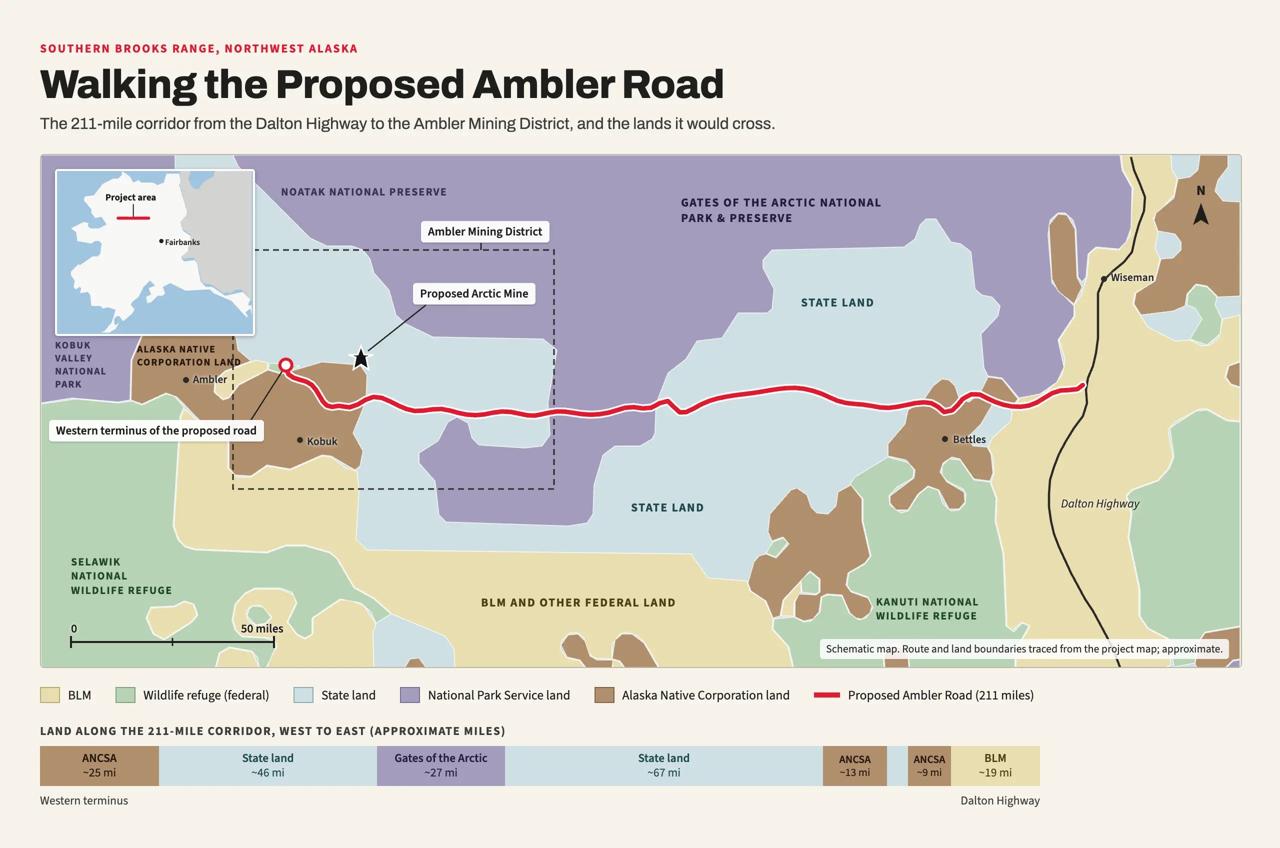
No mining has been done yet — the commercial viability of the mineral deposits remains uncertain, and there are no practical means of transporting ore from the mines to market. But that’s where the road comes in. Back in 2013, the Alaska Industrial Development and Export Authority (AIDEA), first proposed the industrial road. The first Trump administration approved the project in 2020, only for President Biden to terminate the right-of-way in 2024. In 2025, AIDEA successfully appealed that decision directly to President Trump.
Now, a year later, the U.S. government has closed on a $35.6 million investment, giving it an approximately 10% stake in Trilogy Metals. On September 18, the Army Corps of Engineers opened up a public comment period on the environmental review for the Arctic Mine, giving people until November 2 to have their say.

I wanted to give the average person the opportunity to have a truly informed opinion about Ambler Road. The goal was to create a film that depoliticized the issue and documented the actual landscape, rivers, wildlife, and terrain that would be affected. Even if someone could never set foot in the place themselves, they could experience the ecosystem and have a voice in decisions.
I reached out to Ben Kaden, a friend and videographer I’d worked with on a number of outdoor projects, including our film The Columbia River Canoe Project, which chronicled a 1,300-mile, 52-day canoe expedition from my hometown of Butte, Mont., to the Pacific Ocean.
Without really knowing what he was getting himself into, Ben replied right away that he was in.
Not Your Average Hike

This was never going to be an average long-distance backpacking trip. Ben and I spent months preparing for the expedition, and we expected difficulty. The plan was to set out on June 16, 2026, following the proposed road corridor on foot all the way from the Dalton Highway to its western terminus.
Then we would continue a few miles farther to the Ambler River, where a bush plane would pick us up and fly us back to civilization. Hoping to finish in about 3 weeks, I set our goal at 10 miles a day, a seemingly manageable distance that the average Continental Divide Trail hiker would laugh at.

But this wasn’t a well-established trail. In fact, there would be no maintained trails at all, and essentially no human development. We would carry all of our food and gear, along with the extra weight of the film equipment. We knew we would spend much of the expedition in a calorie deficit. Fishing would be required for sustenance rather than recreation.
What we hadn’t anticipated was the terrain itself. Within the first few days, as we tracked speed in hours per mile instead of miles per hour, it became clear that the challenge was going to extend far beyond logistics.
The landscape just didn’t give up mileage.
One of the first challenges was the tundra tussocks. They felt like walking on bowling balls covered in grass. You could never be sure whether your next step would land on top of a tussock or drop into the trough between them. There was no way to establish a normal stride: Every time you hit the top of a tussock and it tipped under your weight, you had to either make a quick adjustment or simply sacrifice and allow yourself to fall over instead of risking a rolled ankle or hyperextended knee.

Then there was the water.
Before the expedition, I read that there were an estimated 2,900 streams, rivers, and creeks along the proposed Ambler Road route that would require culverts if the road were built. While the proposed road runs almost entirely east to west across the southern foothills of the Brooks Range, water naturally drains out of the mountains toward the south.
So instead of following a major river valley, the road would repeatedly cut across drainages, including the Koyukuk River, which flows through the landscape that gives Gates of the Arctic its name, and the Kobuk River, a federally designated Wild & Scenic River.
Still, I thought that number had to be an exaggeration. How could there be 2,900 streams requiring a culvert in only 211 miles? On average, that’s a culvert about every 130 yards.
Now, after having actually walked the route, I still believe the number of culverts is inaccurate. But now I think the figures may be underestimated.

Flowing and standing water was everywhere, and water clung to every leaf of thick willow and alder we fought our way through. Despite waterproof boots and knee-high gaiters, keeping our feet dry was nearly impossible. Over the entire expedition, I managed to make it through exactly one day with dry feet. Ben’s tally was worse: zero days.
Trench foot was a serious concern.
The constant sunlight and warm temps just weren’t enough. Drying our feet, boots, and socks often required a fire, which became part of our morning and evening routine. We’d often get everything just dry enough to put on, only to march immediately out of camp and into the water again.
A Vibrant, Wild Land
The landscape that Ambler Road would pass through is often portrayed as a blank spot on a map. Even from an airplane or helicopter, as the AIDEA road planners and Ambler Metals developers travel, there is no way to truly grasp what the landscape holds. But I can tell you the land is far from desolate.

Thick layers of ground cover spread across the landscape, with mosses in countless shades of green, bright crimson, and orange. Ferns, wildflowers, and grasses grow hip high, creating such dense layers that many birds nest directly in the ground cover rather than in the trees.
We saw birds like spruce grouse and Lapland longspur in every stage of development, from adolescents hopping around, not yet able to fly, to chicks so young they couldn’t open their eyes, calling out for food from their mothers.

There are also alpine-style lakes, some of the most beautiful I have ever seen, sitting at less than 1,000 feet in elevation. The water is clear and pure, supporting Arctic grayling, lake trout, and Arctic char in waters untouched by chemicals or pollutants.
We saw moose standing in the shallows, including a mother with two calves that were still light brown and fluffy. The calves played, splashing around before running into the reeds, where they disappeared completely, not yet tall enough to be seen over the green vegetation.

For 3 days, we walked and camped beneath the Angayucham Mountains, a sub-range whose peaks towered nearly 4,500 feet above us like a conglomeration of some of North America’s most famous peaks. At one end, there was a massif that resembled the Grand Teton and Mount Moran.
A rugged ridge reminded me of Idaho’s Sawtooths. The range was capped by a broad mountain reminiscent of the north face of Granite Peak, Montana’s highest point. If these mountains existed almost anywhere else, they’d be well-known destinations.
Yet in the Ambler Road Corridor, it is all just simply part of the landscape.

We stopped one afternoon on a prominent ridge looking out at wilderness that seemed to go on forever. Ben let out a contented sigh. “Throughout my life outdoors,” he said, “I’ve continually challenged myself to find views completely devoid of human impact. Here, that’s 360 degrees, with no trails, signs, power lines, or any other development.”
He was right.
The landscape is ecologically intact. A place where golden eagles migrate, herds of thousands of caribou pass through, and salmon run its rivers to spawn. A place that’s truly wild.

On July 9, the 24th day of the expedition, Ben and I sat on the edge of a deep, slow-moving creek, blowing up our packrafts for what would be the final time. We had traveled 178 miles, but we were running on fumes.
A few days earlier, we had ruined our electric pump. Sucking mosquitoes through the intake and letting the pump blades chop them up was an incredibly effective way to clear the tent, but a terrible way to maintain the pump. With it now completely gummed up, we were forced to inflate our packrafts the old-fashioned way, with our lungs. Our heads were swimming because of it.
Ben paused, catching his breath and holding the inflation valve of his packraft. “I ate about 10 Pepto Bismol tablets this morning.”
I looked over at him, surprised and concerned. “Your stomach all good?” Any kind of flu this far into the wilderness would be a serious problem.
Ben looked back at me as if I’d just asked something ridiculous. “My stomach’s fine,” he said, wrinkling his forehead further. “I ate them because they were pink and looked like candy.”
I sat there and stared back at him. Two days ago, Ben had cut open our tube of toothpaste to eat it. Now he was starting in on the first-aid kit.
I really have pushed us about as far as we can go.
We had been out of food for 3 days — and on half rations for almost 10 days before that. We had eaten as many fish as we could and were still dropping weight. We didn’t know it yet, but we’d each lost more than 10% of our body weight, 15 and 22 pounds, respectively.
We thought about food constantly. Pizza with extra cheese. Cheeseburgers with all the fixings.
We dreamed about soft beds, hot showers, air conditioning, and the simple luxury of living indoors.

We wanted home.
Yet at the same time, we wished we could stay forever.
Two days later, on our 26th day in the wilderness, we reached a lake where a float plane could pick us up. We could go no farther. Twenty miles short of the terminus of the proposed Ambler Road, we made the difficult decision to use our satellite phone to call for extraction.
I had failed in my goal of traversing the entire length of the proposed road. But we had accomplished the purpose of the expedition: to document the place and what stands to be affected if the road is built.
Before the expedition, my motivation was largely intellectual and conservation-driven. I looked at the project like an investigative journalist. With construction possibly beginning as soon as the spring of 2027, I wanted boots on the ground to show people the landscape at risk if Ambler Road is built and the area is opened to industrial-scale mining.

Somewhere out there, my mission became more than just reporting.
Through all the toil and struggle, the mosquitoes and wet feet, I found inside myself a deep desire to protect this place.
Now I think about drinking from the streams and eating fish from their waters. I think about spending almost a month in the wilderness without seeing the scars of hundreds of mines, a constant flow of haul trucks, or a road cutting through one of the largest remaining intact ecosystems in North America. I think about the cleanest air I’ve ever inhaled and the indescribable feeling of being somewhere that still functions naturally, as it has for thousands of years.
To return and see all that changed. To see a landscape I experienced as whole and wild permanently altered would be beyond heartbreaking.


