A remote Appalachian ghost town, the spirits of cave-dwelling invalids, a ghost fleet of would-be wartime ships, the fatal wreckage of a B-17 Bomber, a floating corpse in a shipwreck. Each of these spooky historical sites proves that sometimes the truth from the past is stranger and spookier than fiction.
Some ghost stories are best told around a campfire, but these five haunted histories are more chilling in person. From an abandoned Appalachian homestead to a cave-turned-sanitorium that was the site of failed medical experiments, each adventure on this list takes real effort to reach: a hike, a paddle, a lantern-lit trek, or a technical dive. Pack accordingly, if you dare!

Ghost Town of Lost Cove
Pisgah National Forest, N.C./Tenn.
When I arrived at the trailhead on a brisk but sunny October morning, the gravel pull-off on Forest Service Road 278 was suspiciously quiet. I’ve lived in southern Appalachia for over a decade, and a nearly empty lot during peak leaf-peeper season is unheard of.
I was there to hike to Lost Cove, an abandoned mountain settlement deep in the hollers on the North Carolina-Tennessee line, and while I had a friend and my dog as company, I wondered if we were making a mistake. The journey to Lost Cove is rugged. You must reach the remote settlement on foot. The trail drops nearly 2,000 feet over three miles, every step descending further into isolation. For residents of Lost Cove, remoteness was the point.
What Happened to Lost Cove?
Described as “one of eastern America’s most legendary ghost towns” by Unicoi County historian Pat Alderman, Lost Cove was once a thriving settlement that survived off-grid for almost one hundred years. Its origins are debated, but most surviving oral histories agree that Lost Cove was first inhabited during the Civil War by Union soldiers. Other families soon followed, seeking refuge within the region’s deep hollers. In its prime, Lost Cove was home to 100 people generations deep, only to vanish in the mid-twentieth century.
So what happened to Lost Cove? It’s a familiar story of Appalachian diaspora. The once self-sufficient mountain community grew increasingly reliant on the outside world for education and employment opportunities, and many young men enlisted in World War II. For Lost Cove, dependence on the outside world was the final nail in its coffin.
After two hours of steep, moss-slicked switchbacks, we reached an agreeably flat glen. That’s when I saw it— a rusting rooftop poking out through thickets of early-succession beech and sourwoods. The home of Chester Bailey, a descendant of one of the original Lost Cove pioneers, stood quietly among the trees.
We kept East along an unmarked path that led to more relics: another dilapidated structure, believed to be the small home of Reverend Bob Miller, and stone steps to the Lost Cove Free Will Baptist Church.
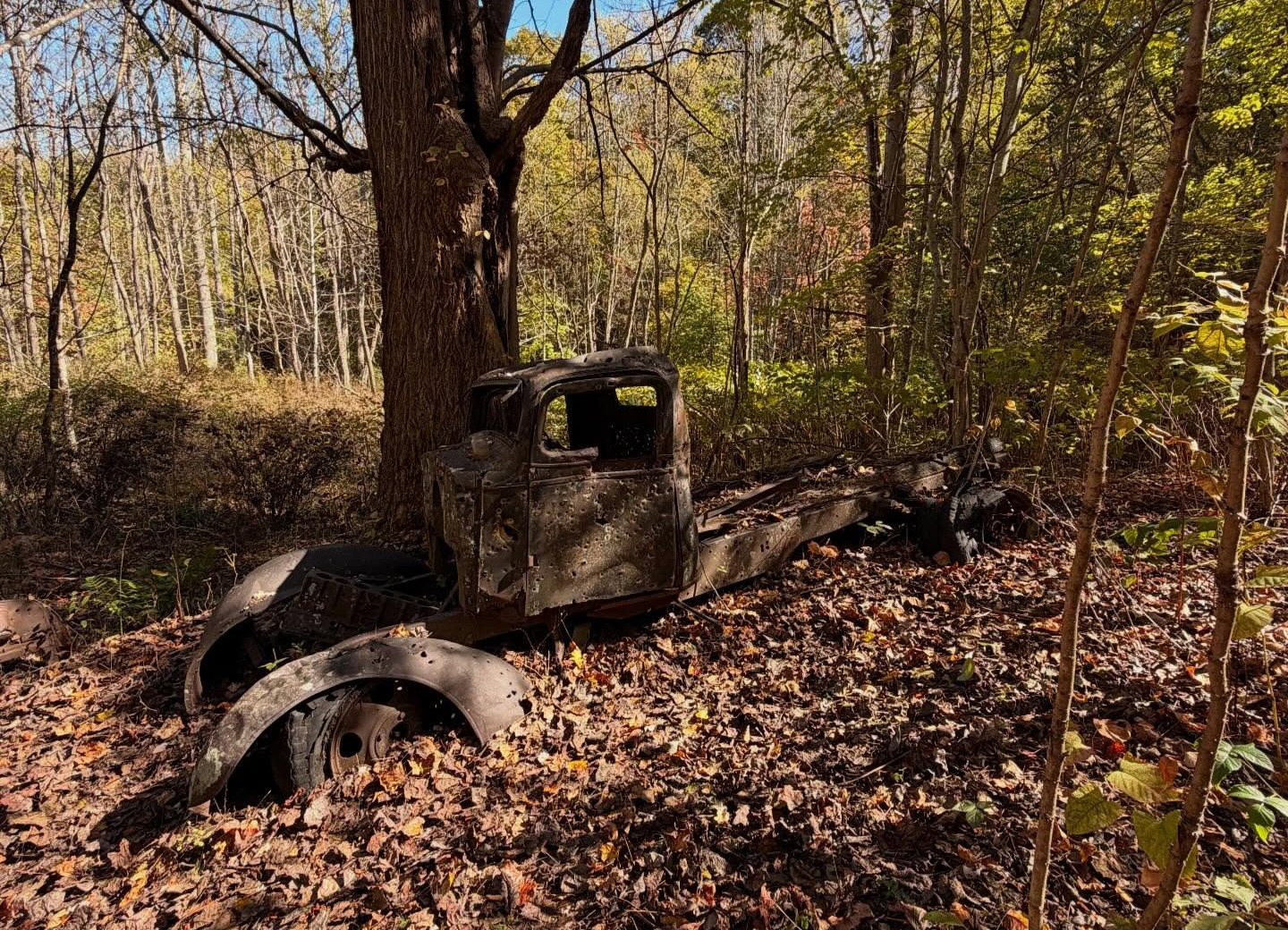
Backtrack towards the Nolichucky River to find more artifacts: river rock chimneys standing without a house, a rusting pickup truck bearing evidence of target practice, and natural springs trickling down the mountainside. We spotted what looked like cisterns, or possibly remnants of old stills. During its heyday, Lost Cove was a prolific supplier of moonshine.
Things to Know
- Location: Lost Cove sits in the Poplar Gorge above the Nolichucky River on the Tennessee-North Carolina border, in Yancey County (36°03’11.6″N 82°22’41.2″W), within Pisgah National Forest.
- Getting there: The trail begins in the Flat Top Mountain area. From Spivey Gap, turn onto White Oaks Flat Road, then onto unpaved Flat Top Road, which leads about 2 miles to the trailhead. Parking is just beyond it.
- The hike: 6.8 miles out and back with 2,086 feet of elevation gain, rated hard (per AllTrails). Other guides describe it as very strenuous, with a descent of about 1,200 feet to the ruins and the same climb back out. Plan on about two hours each way, plus time at the ruins.
- Access: The settlement can only be reached on foot.
- What you’ll find: See several remaining structures and a cemetery, reached from the trail. Allow at least an hour to explore.
- Protected land: The Southern Appalachian Highlands Conservancy bought a 95-acre portion of the old settlement in 2012. Leave structures and artifacts as you find them.

Tuberculosis Huts & Mummies of Mammoth Cave
Mammoth Cave National Park, Kent.
Mammoth Cave National Park in the rolling hills of central Kentucky has a lot of dark history: spontaneous mummification, failed medical experiments, and ghostly hauntings within the longest cave system in the world.
Spanning 52,830 acres of wilderness, Mammoth Cave National Park is, well, mammoth. Designated as both a UNESCO World Heritage Site and an International Biosphere Reserve, over 400 miles of caves have been charted with no end in sight. The karstic cave system has a temperate micro-climate, maintaining a comfortable 54° year-round. The dry air is rich in calcium-magnesium carbonate, nitrate, and sulfate from the abundance of limestone and dolomite. Turns out this very environment aids in natural mummification.
During the height of the War of 1812, miners extracted saltpeter, a material used for gunpowder. While digging in Short Cave, a part of the Mammoth Cave system, miners made a hair-raising discovery— a well-preserved corpse, its skin, teeth, and auburn hair intact, entombed in a crypt ten feet below the cave’s floor. The prehistoric woman was found wrapped in ornate buckskins and adorned in a necklace of fawn hooves. Eventually, this mummy named “Fawn Hoof” would be claimed by the Smithsonian, but not until nearly 100 years of touring the U.S. as a freak show attraction. She made appearances at the World’s Fairs in 1876 and 1893. To date, at least six mummies have been unearthed in Mammoth Cave.
Following the totally sane line of thinking that if this cave environment could keep bodies preserved for thousands of years, it MUST have healing properties, Dr. John Croghan purchased Mammoth Cave and turned it into a sanatorium. In the winter of 1842, 16 tuberculosis patients moved into huts underground, hopeful that the cave’s air would cure them…but it didn’t. The failed experiment lasted about five months, with five patients perishing from their illness, their bodies laid out on what is now called Corpse Rock. Today, two of Croghan’s tuberculosis huts still stand, and visitors and park rangers alike have long reported hearing mysterious coughing nearby.

You can see Mammoth Cave the way Dr. Coghan’s tuberculosis patients would have: by lantern. The three-hour Violet City Lantern tour winds through the cave’s history, passing through enormous tunnels along the way. Expect some work, though. The historic dirt trails climb and drop over some seriously steep hills. If you like to hike and want a different way to experience the cave, this is the one. On this tour, you will visit Corpse Rock, and guides will extinguish their lanterns, offering the experience of pure sensory deprivation. During this part of the tour, visitors have reported being shoved by unknown entities as well as feeling the eerie sensation of being watched.
Things to Know
- Location: Mammoth Cave National Park Visitor Center, Mammoth Cave, Kentucky.
- Tickets: Reservations are strongly recommended and are available through Recreation.gov. Tickets are $32 for adults, $27 for youth, and $16 for Senior and Access Pass holders. The pass discount applies only to the passholder.
- Age requirements: Visitors must be 6 or older, and anyone under 16 must be accompanied by an adult 18 or older. Only adults 18 and older may carry lanterns.
- What to expect: The tour lasts three hours and covers steep hills, low lighting, and uneven terrain with no handrails or electric lighting. There are no restrooms along the way, and evacuation to a hospital could take several hours.
- Lanterns and lights: Flashlights are prohibited to preserve the tour’s nostalgic feel. Lanterns may cause discomfort for visitors with respiratory conditions.

Ghost Fleet of the Potomac
Mallows Bay-Potomac River National Marine Sanctuary, Md.
Forty miles south of Washington, D.C., more than 100 abandoned vessels from World War I rest in the shallows of the Potomac. A century ago, these hastily built wooden ships emerged from a wartime frenzy of production. Today, they are a ghostly fleet, ribs of iron and splintered wood rising from the tidal waters as nature slowly reclaims them.
In response to the mass destruction of merchant ships by German U-boats during the First World War, the US Government instituted the Emergency Fleet Corporation. Its mission was plain: build 1,000 freighters as fast as possible, using whatever labor available. Of 734 ships ordered, only 98 were delivered— and not a single ship ever reached a European port.
The Emergency Fleet failed, and the $300 million investment was sold off for scrap. The government hauled the unused hulls up the Potomac, burned, and left to rot; the river slowly swallowed the ships and the patriotic pride they once symbolized.
At low tide, decaying hulls and rusting carcasses surface, calling all urban explorers. Paddlers can investigate the Ghost Fleet with a group tour or on their own. Don’t miss Three Sisters Cove, where the SS Mossabee, the SS Dertona, and an unidentified vessel form a creepy, artificial reef of wreckage. The site has been a National Marine Sanctuary since 2019, and visitors can also observe the bald eagles, osprey, vultures, and herons that nest among the deserted ships.
Things to Know
- Location: Mallows Bay Park, 1440 Wilson Landing Rd, Nanjemoy, MD 20662
- Guided tours: Charles County Parks, Recreation & Tourism leads guided kayak tours of the Ghost Fleet from May through October. See here for tour dates, prices, and online registration.
- What’s included: An introductory kayak lesson, guided tour, kayak, paddle, and personal flotation device.
- Experience level: No experience is necessary. Tours with an experienced guide at a relaxed pace.
- Age requirements: Participants must be 8 or older. Those ages 8 to 17 must be accompanied by an adult.
- Paddling on your own: Groups of 10 or more must pre-register at least two weeks ahead to limit congestion at the boat ramp.

1952 B-17 Bomber Wreckage & Tubal Cain Copper Mine
Buckhorn Wilderness, Olympic National Forest, Wash.
It was a complete white-out. A fierce blizzard slammed the Pacific Northwest in January of 1952, but the crew of a B-17 Flying Fortress was already flying back to McChord Air Force Base after responding to a rescue mission for a freighter stranded in Canadian waters. Low visibility, strong winds, and the constant threat of a freezing engine tormented the eight souls on board. Succumbing to the odds, the vulnerable plane struck a ridge near Buckhorn Mountain and slid nearly 2,000 feet into the canyon below. Three of the eight crewmen died on impact, leaving the surviving five to fend for themselves in a Washington blizzard.
In Olympic National Forest outside Sequim, the Tubal Cain Mine Trail leads hikers to the wreckage of this very B-17. Decades later, large pieces of twisted aluminum, engine parts, and even wing fragments still lie scattered along the boggy forest floor.
From the trailhead, you’ll cross Silver Creek and follow a well-maintained trail through rhododendron tunnels, groves of hemlock drenched in lichen, and plenty of fungi. After about three miles, look for Tull Canyon Trail— this is the fork that will take you to the crash site. A steep half-mile slog and you’re there, just look for the unnerving heaps of fuselage and landing gear rusting in the spongy humus, an eerie reminder of our own impermanence.
If you dare, hike another half-mile on the Tubal Cain Mine Trail and explore what’s left of the abandoned copper and manganese mine. The mine was a total flop. It never turned a penny, and an avalanche destroyed it in 1912. While not safe for exploration, the mine still intrigues— tunnels extend almost 3,000 feet into the mountainside.
Things to Know
- Location: Tubal Cain Trail (#840) trailhead, Olympic National Forest, Hood Canal Ranger District, Wash. (47.8861, -123.0913)
- Getting there: From US 101, turn west on Louella Road just south of Sequim Bay State Park, then follow Palo Alto Road and a series of Forest Service roads (FS-2880, then FS-2870) for about 21 miles total. Part of FS-2880 is narrow and not recommended for trailers or motor homes. Save the full directions before you go, since app-based directions can be unreliable out there.
- The hike: 8.9 miles round trip with 2,142 feet of elevation gain, rated moderate to hard. The Tull Canyon spur to the 1952 B-17 crash site branches off at about mile 3 and gains 450 feet in 0.6 mile.
- Camping: Established campsites are available near the start of the trail and on a plateau at the wreckage site. Water flows through the debris-strewn valley; filter it upstream of most of the debris.
- Registration: Sign in at the trailhead kiosk.
- Leave No Trace: Please leave the wreckage as you find it so others can discover the site, too.

SS Kamloops Shipwreck
Isle Royale National Park, Lake Superior (the lake that never gives up its dead)
“I am the last one left alive, freezing and starving to death on Isle Royale. I just want mom and dad to know my fate.”
These were the last words of Alice Bettridge, a young stewardess aboard the SS Kamloops, a Canadian freighter that vanished into the depths of Lake Superior in 1927. The crew survived the wreck and drifted ashore on Isle Royale, but died of exposure. Alice wrote her final message and sealed it in a bottle. One year later, the bottle washed up near the mouth of the Agawa River, drifting over 200 miles east. Despite concerns that the letter was a hoax, Alice’s parents confirmed her handwriting was a match.
We know Alice’s fate. But what happened to the ship?
The SS Kamloops departed with a cargo of papermaking machinery in late November and traveled across Lake Huron without incident. Late-season brought unpredictable weather, and the crew was on edge. When the ship reached Lake Superior, a winter storm was raging. The lake swelled and spat, covering the small freighter in thick ice. The SS Kamloops was last seen near the southeastern shore of Isle Royale at dusk on December 6.
The following spring, bodies of the crew began washing ashore, but the fate of the ship remained a mystery. Half a century later, a Minneapolis sport diver noticed shadowy wreckage on an exploratory dive. 260 feet down at the base of an underwater cliff, the SS Kamloops had become a watery tomb. Lake Superior’s frigid waters preserved the shipwreck, and divers have seen crates of shoes, a roll of Life Savers candies, and even a well-preserved corpse floating in what was once the engine room.
Things to Know
- Dive type: Technical dive only. The wreck sits about 260 feet down, which typically calls for trimix and rebreathers. Experienced divers only.
- Getting there: The only regular commercial charter is Isle Royale Charters, which leaves from Grand Portage, Minn., for a 3 to 4 hour boat ride and books years in advance.
- Permits: Each diver must register at the Rock Harbor, Windigo, or Houghton Visitor Center before diving and return the completed permit after the trip. See the NPS scuba page.
- Water conditions: Lake Superior’s surface temperature rarely tops 55°F, and below 50 feet it’s 34 to 37°F. You’ll want a full wetsuit or drysuit.
- Air fills: There are no facilities for filling dive cylinders at Isle Royale, so arrive with everything you need.
- Safety: Diving here is remote, and emergency care isn’t immediately available. The closest recompression chambers are in Minneapolis and Milwaukee. In an emergency, contact park rangers or the Coast Guard on marine radio channel 16.
- Regulations: Federal law prohibits removing or disturbing shipwrecks and artifacts. Wash all gear in warm chlorinated tap water and dry gear and wetsuit for seven days before diving in the park to prevent the spread of invasive species. Dive sites and boats must display a diver-down flag.